NEWS SENSORI E NOVITÀ RICEVITORI GPS

OUSTER – Firmware 2.1.1: Better Perception Performance with Improved Reflectivity and Signal Multiplier mode

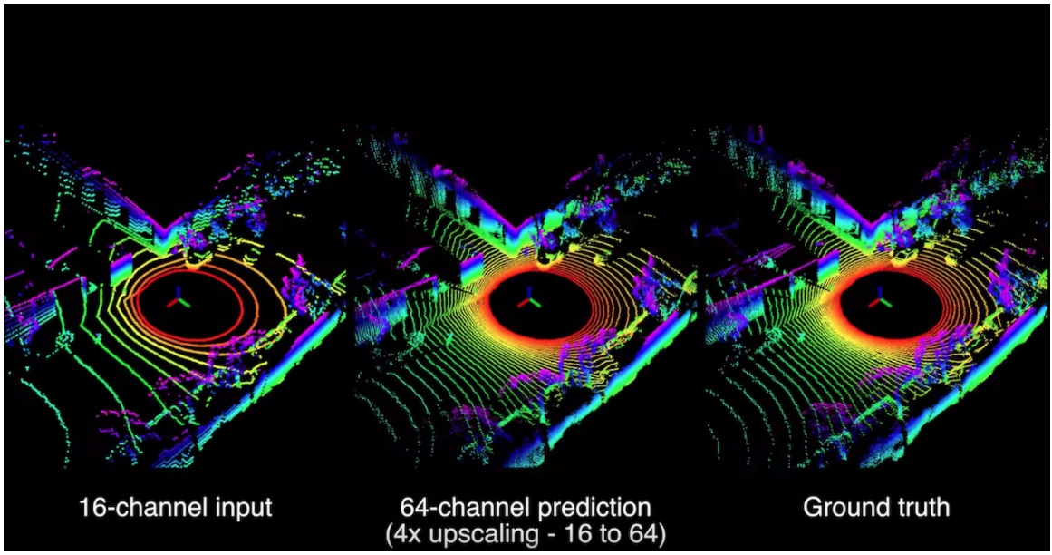
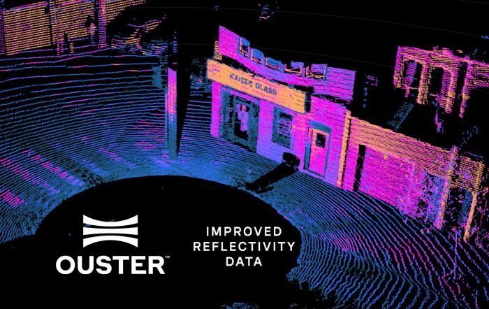
One of the major advantages of using Ouster Digital Lidar sensors is access to consistent firmware updates that dramatically improve sensor performance. With Firmware 2.1.1 we are continuing this trend, adding features that dramatically improve our sensors’ perception performance, improve detection probability of our sensors, and make them easier to work with.

Firmware 2.1.1 includes three major feature upgrades, along with bug fixes, to make our sensors even more effective for autonomy and smart infrastructure applications.

Per maggiori informazioni: Firmware 2.1.1: Better Perception Performance with Improved Reflectivity and Signal Multiplier mode | Ouster


Oppure contattaci:

https://www.lunitek.it/contatta-sensoristica-e-acquisizione-dati/

Luglio 1, 2021 / by / in
WEISANG – Update to the brand new FlexPro 2021

Update to the brand new FlexPro 2021

New License Structure

With the new version of FlexPro 2021, we are simplifying the product structure of FlexPro so that the individual editions can be better distinguished from each other. The following editions are available now:

  • FlexPro Basic includes data presentation, visual and mathematical analysis, no options can be added.
  • FlexPro Professional includes data presentation, visual and advanced mathematical analysis, teamwork functions, high-performance calculations, video analysis, measurement series analysis, control panel & controls, and automation, options can be added.
  • FlexPro Developer Suite the complete package with all the above features, plus all available options are included.

To our maintenance customers with a Standard Edition, we offer the upgrade to the Professional Edition free of charge. The other option is that you are satisfied with the functionality of the Basic Edition and switch to it. In any case, in the upcoming maintenance period, the price for maintenance will be calculated on the basis of the edition in use at that time. If you have worked with a View license so far, we also offer you the possibility of a free upgrade, in this case to the Basic Edition, with a corresponding adjustment of the maintenance costs in the future. Here you find detailed information about the FlexPro Editions.

Selected features of the new FlexPro 2021

  • State-of-the-art interactive data analysis
  • New row table and improved column table
  • New control panels and controls
  • Redeveloped order analysis using a new algorithm
  • Strain gauge rosette transformation
  • New import schemes for binary data

This list is by far not complete! Please have a look at our website to get to know the new features in detail. We are sure you will find many useful things that you can use immediately for your routine tasks.

For Maintenance Customer – This is how you update:

Login to your MyWeisang section of the website under your services click on FlexPro Maintenance |Open | Request update.


Per maggiori informazioni contattaci:

https://www.lunitek.it/contatta-sensoristica-e-acquisizione-dati/

Luglio 1, 2021 / by / in
OUSTER – University Research with Ouster Lidar

A large fraction of Ouster’s employees started their careers in research and academia. We recognize the critical role research continues to play in robotics and from the start have supported researchers through steep discounts on our products. Today we’re furthering our support with the first of a series of blog posts highlighting the incredible work of our university partners. Email us if you’d like to be mentioned in a future post!

University of Pennsylvania, GRASP Lab

UPenn’s GRASP Lab is a robotics lab of 250 graduate students tackling challenges in-ground and aerial vehicles, machine learning, and automation. Here we highlight the Kumar Lab research group working on the DARPA Subterranean Challenge.

The SubT Challenge is a 3-year competition to develop solutions to map, navigate, and search underground environments during time-sensitive disaster response scenarios, when settings can degrade drastically and create unknown hazards for first responders. The competition consists of three circuit events in different underground environments, culminating in one final event in August 2021.

The competition kicked off in September 2018 when DARPA selected nine teams to compete, including UPenn’s GRASP Lab working in collaboration with Ghost Robotics and Exyn Technologies. The team is currently preparing for the first circuit event scheduled to take place this August!

The Kumar Lab is creating multiple robotics platforms that can achieve long periods of autonomy underground. To navigate through tunnel systems and collect high-resolution data, the team chose to use the Ouster OS1-64 lidar sensor. We spoke with team member Shreyas Shivakumar, a computer vision and robotics Ph.D. student, to learn more about why they picked Ouster for a critical function of their SubT robot.

The OS1-64 was integrated with a color camera outdoors

“What first stood out to us was the ease of use and integration. It takes about 10 minutes to go from taking the OS1-64 out of the box to having it stream a nice point cloud to you on Rviz” said Shreyas. A quick test outdoors with a color camera fusion also demonstrated how easy it was to discern objects from the point cloud alone.

This month, the team tested their Ouster and Ghost Robotics platform at a SubT Integration Exercise and we hope to have more updates soon on their accomplishments!

Stevens Institute of Technology

SIT is a research university in New Jersey dedicated to engineering. One of the projects SIT’s Robust Field Autonomy Lab, led by Professor Brendan Englot, is working on uses machine learning to enhance lidar resolution for ground vehicles. They’ve successfully increased the resolution of sparse point cloud data by projecting the 3D data into 2D range images to simplify upstream processing, applying a convolutional neural network to upsample the data, and then converting the upsampled 2D data back to 3D.

SIT is the first group to attempt this approach to lidar super-resolution enabled by deep learning. While to date they have trained their neural network using only computer-generated data from a simulation environment, they are using the OS1-64 lidar to validate their algorithm on real-world data.

Architecture for high-resolution lidar predictions using low-resolution data

In order to create their validation dataset, the team mounted an OS1-64 on a ground vehicle, gathered 64-beam data, and removed 75% of the scan lines to obtain 16-beam data. With the Ouster lidar, the data already comes out in an efficient 2D format, so the team was able to skip the step of projecting the 3D point cloud into a 2D range image. This generated 2 datasets: 16-beam data for passing through their algorithm and 64-beam ground truth data to compare against the result. As you can see below, the predicted data is very close in resolution to ground truth data.

Testing with Ouster dataset using OS-1-64

The team at SIT believes lidar users could apply this neural network to gather denser point clouds of difficult environments or heavily populated areas. Even as lidar resolution improves to 128 beam resolution and beyond, this approach could be applied for still greater resolution.

Mississippi State University, HALO Project

The Center for Advanced Vehicular Systems at MSU is a multi-disciplinary automotive research center with over 300 researchers working on projects ranging from designing new steel alloys, to modeling airflow around rockets. The MSU Halo Project, named after the exotic cars automakers sell that create a “halo” effect on the brand, is a self-driving, all-electric supercar designed to showcase the team’s expertise in automotive engineering.

“Within the Halo Project, our autonomous tech team is the largest group.  They are dedicated to finding solutions for the 99% of the Earth that is not paved,” said CAVS Associate Director and HaloProject leader Matt Doude. There’s currently a lot of cool autonomous vehicle research focused on on-road use cases, but the team believes off-road environments are where autonomous technology can most exceed human abilities. In off-road environments, humans have to make imprecise judgments about traversability, whereas lidar can measure exact dimensions of obstacles and a vehicle dynamics model can determine whether the vehicle can clear a given log, hill, or hole with certainty.

MSU Halo has one of the only off-road autonomous vehicle proving grounds in the world, where they’ve been testing Ouster lidar. The team has three Ouster lidar units on their vehicle – one to scan the horizon for objects and potential obstacles, and two to map the terrain directly in front of the vehicle. The horizon scanning lidar on top of the vehicle feeds data into a neural network used to classify objects and generate a 3D occupancy grid. The other two lidar sensors are mounted on the front of the vehicle, tilted on two axes, to ensure that the beam paths are fairly normal to the ground and that all of the beams intersect the ground in front of the vehicle. Using the data from these three lidar sensors, the team can precisely model the terrain in front of the vehicle to complete traversability estimation.

MSU Halo vehicle mapping the woods and off-road terrain with Ouster OS1-64

The MSU Halo team is compiling the most comprehensive, detailed, multi-modal set of off-road autonomous vehicle data, and plans to open-source that data set on their website. They hope to spur mobility beyond urban centers to rural, undeveloped, and remote environments.


Per maggiori informazioni contattaci:

https://www.lunitek.it/contatta-sensoristica-e-acquisizione-dati/

Giugno 18, 2021 / by / in
NOVATEL – Avviso di EOL per i sistemi OEMStar & Ag-Star NOVATEL

NovAtel Inc. is announcing the End of Life of the following family of products:

OEMStar

AG-Star

These products will be available for order until:

1 September 2021 (or until inventory has been depleted; orders are non-cancellable) 

Shipments may be scheduled for no later than:

16 December 2022 

NovAtel will continue to support and repair these products until:

16 December 2024

For a complete list of affected part numbers and the associated replacement part numbers, please refer to the table below:

Discontinued Part Number Replacement Part Number
OEMSTAR- (all variants) OEM7500 or OEM719
AG-STAR- (all variants) SMART2


Notes:

For a complete listing of NovAtel products at end of life, including the expiration of support and repair for those products, please refer to the list of the discontinued products on the NovAtel website at www.novatel.com/products/discontinued-products


Per maggiori informazioni contattaci:

https://www.lunitek.it/contatta-sensoristica-e-acquisizione-dati/

Giugno 18, 2021 / by / in
NOVATEL – New 7.08.02 firmware release for CPT7 products

New 7.08.02 firmware release for CPT7 products

As an existing customer using our CPT7 enclosure, we wanted to notify you about a new firmware release, 7.08.02, which coincides with the release of two new CPT7 variants. The 7.08.02 firmware includes azimuth performance improvements and general updates to your current CPT7 unit and is now available for all customers.

Our two new CPT7 variants, the CPT7 and CPT7700, have the same low size, weight, and power offerings with additional hardware features. We will continue supporting the legacy CPT7. Any new purchase orders will offer the upgraded CPT7 or new CPT7700 variant.

UPDATE NOW


New hardware features on CPT7 variants

The updated dual-antenna CPT7 enclosure includes the OEM7720 receiver board, while the single-antenna variant CPT7700 uses an OEM7700 card supporting a higher availability of frequencies. Both devices include a Honeywell HG4930 AN04 IMU to support our SPAN GNSS+INS technology for position, velocity, attitude, and heave measurements.

New features of the CPT7 and CPT7700 enclosures include:

  • Support for wheel sensor data including ticks and direction
  • Onboard data storage up to 16 GB for real-time data logging
  • Low size, weight, and power for technical scenarios where space is at a premium
  • SPAN GNSS+INS technology for continuously available inertial measurements
  • LED status indicators
  • Optional high IMU data rate (400 Hz) for enhanced data resolution


Per maggiori informazioni contattaci:

https://www.lunitek.it/contatta-sensoristica-e-acquisizione-dati/

Giugno 4, 2021 / by / in
NOVATEL – ADAS and Automotive Autonomy through the new PIM222A

Launching today is a new precise positioning product in our family of automotive GNSS solutions for Advanced Driver Assistance Systems (ADAS) and autonomy: The PIM222A.

Created in collaboration with STMicroelectronics, the PIM222A module leverages SPAN GNSS+INS technology to deeply couple satellite and inertial measurements for enhanced tracking and continuous availability of position, velocity and attitude, even when satellite signals are interrupted.

See how this new module maximizes integration flexibility and scalability to low-, medium- and high-production volumes.


Per maggiori informazioni contattaci:

https://www.lunitek.it/contatta-sensoristica-e-acquisizione-dati/

Maggio 21, 2021 / by / in
NOVATEL – Introducing GAJT-410MS: New marine anti-jam technology

Marine anti-jamming technology for civilian and military applications delivers assured PNT

Interference, jamming, and spoofing are growing threats in marine environments around the world. This latest addition in the GPS Anti-Jam Technology portfolio is a low size, weight, and power (SWaP) variant to protect civil and military operations from interference and jamming in the marine environment, with jammer direction-finding capabilities for enhanced situation awareness.

The GAJT-410MS protects your crew, vessel, and cargo from interference, jamming and spoofing through dynamic protection on M-Code signals as well as GPS L1/L2, Galileo E1, QZSS L1/L2, and SBAS L1. Its marine-hardened shell is optimized for the harsh marine environment, wherever your application takes you.

Using adaptive digital null-forming algorithms to identify interference and jamming signals, adjusting its gain on reliable satellite signals to maintain your PNT. Its direction-finding capabilities enable you to identify and locate the source of jamming signals and optimize situation awareness of your RF environment.

This commercial off-the-shelf, non-ITAR solution is easy to install or retrofit onto existing fleets, enabling assured PNT for continuous operations, cybersecurity, and safe navigation at sea.

Per maggiori informazioni contattaci:

https://www.lunitek.it/contatta-sensoristica-e-acquisizione-dati/

Maggio 12, 2021 / by / in
OUSTER – Ouster Supports Python

Ouster software team has released new package that allows customers to use Python to work with the data from our sensors, called the Ouster SDK. 

It lets developers interface with Ouster lidar sensor data directly in Python, simplifying algorithm development, accelerating prototyping, and saving time. The SDK package is underpinned with C++, ensuring that data is processed fast. On top of the C++ base, code sits a Python interface layer that gives developers easy access to all the open-source libraries and fast scripting that Python is known for.

We know that a lot of our customers and Ouster users are waiting for this, so feel free to share it with all customers. Check out the Developer Tools section of the downloads page https://ouster.com/downloads/


Per maggiori informazioni contattaci:

https://www.lunitek.it/contatta-sensoristica-e-acquisizione-dati/

Maggio 4, 2021 / by / in
XSENS – Webinar: MTi-680G +RTK | Outdoor real-time 3D positioning of Autonomous Vehicles, Mobile Robots and Drones on the 29th of April!

Vorremmo invitarti al nostro webinar: MTi-680G +RTK | Posizionamento 3D in tempo reale all’aperto di veicoli autonomi, robot e droni giovedì 29 aprile alle 11:00 CEST.

Se sei interessato allo sviluppo di veicoli autonomi o al posizionamento accurato in tempo reale di veicoli all’aperto/robot mobili, questo è il webinar perfetto per te!

In questo webinar Ioannis Papadimitriou, Product Specialist Inertial Sensor Modules presso Xsens, spiegherà come utilizzare e applicare il sistema MTi-680G con Real-Time Kinematic Positioning (RTK).


Agenda:

  • Come ricevere le correzioni RTK
  • Come configurare l’MTi-680G
  • Ottieni dati in tempo reale dall’MTi-680G con precisione RTK
  • In pratica
  • Domande e risposte


Non vediamo l’ora di incontrarti online il 29 aprile! Per partecipare al webinar: Register here!


Aprile 26, 2021 / by / in
NOVATEL – Waypoint 8.90R2 Maintenance Release

NovAtel Announces Version 8.90.4416 release for Waypoint Post-Processing Products

21 April 2021

Hexagon | NovAtel is pleased to announce their Waypoint post-processing software now includes built-in support for HxGN SmartNet, the world’s largest GNSS reference station network. HxGN SmartNet offers reliable coverage and local support from thousands of Real-Time Kinematic (RTK) reference stations worldwide, providing centimeter-level accuracy necessary for machine control and automation, surveying, and asset mapping.

With Waypoint post-processing software’s new built-in HxGN SmartNet support, users requiring highly accurate post-mission measurements have a simpler process to integrate precision RTK corrections and RINEX data into their surveys. Waypoint software users with a valid HxGN SmartNet subscription can enter their login credentials in their Preferences menu to integrate their services.

Along with HxGN SmartNet support, features now available in the 8.90.4416 release include:

  • Local license manager interface for offline activation and offline management of Waypoint software licenses
  • Improved support for users using PPP corrections to calculate local base station coordinates and automate differential processing of short surveys

A full listing of all changes is available in the version history documents here:

Customers that have already upgraded to 8.90 will be able to auto-update to this maintenance release from within the software. Customers that are on older versions of Waypoint will need to contact customer support to update their license, provided that their PCS is up to date.


Per maggiori informazioni contattaci:

https://www.lunitek.it/contatta-sensoristica-e-acquisizione-dati/

Aprile 26, 2021 / by / in